

GAGAN Messaging Service Inaugurated
The latest venture dubbed as GEMINI, has been developed through a collaborative effort between the AAI and the Indian National Centre for Ocean Information Services (INCOIS) under the Ministry of Science & Technology
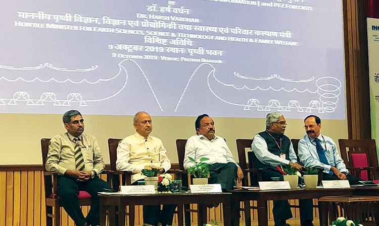
October 9 this year will go down in the history of space ventures by the space and civil aviation agencies of India as a “Red Letter Day” as it was on this day that the nation witnessed another significant step forward in the development of space-based communication system in the country. It was on this very day that the Union Minister of Science & Technology and Earth Sciences, Harsh Vardhan, formally launched, GAGAN Enabled Mariner’s Instrument for Navigation and Information (GEMINI) App & Potential Fishing Zones (PFZ) Forecast service of Indian National Centre for Ocean Information Services (INCOIS) in presence of Secretary MoCA, Chairman-AAI, Director-INCOIS, Member (ANS)-AAI and senior officials from AAI & INCOIS.
GPS Aided Geo Augmented Navigation (GAGAN) is India’s Satellite-Based Navigation System (SBAS) developed by Airports Authority of India (AAI) in coordination with Indian Space Research Organization (ISRO). GAGAN provides Air Navigation, RNP 0.1 & APV 1, over India FIR & India landmass respectively consistent with International Civil Aviation Organization (ICAO) Standards.
GAGAN Signal-In-Space (SIS) is available on a 24x7 basis from GAGAN geostationary Satellites. Although primarily meant for Civil Aviation, the GAGAN signal can be used by a vast majority of non-aviation users such as intelligent transportation, fishing, maritime, highways, railways, surveying, geodesy, precision agriculture, telecom industry, personal users of position location services, etc in the Indian sub-continent. The applications of GAGAN to various users are enabled through the dissemination of GAGAN messages through the GAGAN geostationary satellites.
CONCEPT
GAGAN is the first Satellite-Based Augmentation System (SBAS) in the world which has been certified for approach with vertical guidance operating in the equatorial ionospheric region. This system covers the air space over continents extending from Africa to Asia and extending to Australia. The system has expansion capability for seamless navigation services across the region. The system is also interoperable with other international SBAS systems which imparts its enormous flexibility. It is also of significance that India is the fourth country in the world to implement an SBAS system for civil air navigation.
Timely provision of effective information allows people exposed to hazard to take appropriate action to avoid or reduce the risk and prepare better for effective response. The current early warning conventional methods have certain limitations such as Non-availability of Warning and location information with the same system, No guarantee for timely service, Limited coverage area, Last mile communication problem, etc.
AAI has examined the potential and has taken up the project to introduce broadcasting of alert messages such as Early Warning messages on the occurrence of natural disasters, calamities, dangers for the safety of life, Search and Rescue Messages, Relief, and mitigation related messages, Meteorological information, etc. by utilizing existing GAGAN infrastructure. The user will be in a position to receive the messages using GAGAN enabled Smart-Phones, receivers or a device that can process GAGAN signal.
GAGAN presents a unique and efficient solution to the delivery of one-to-many messages. To reach the maximum number of people in the target area with a reliable information service, a specific technical solution is in the process of development using GAGAN satellites. GAGAN provides a robust inter-operability framework for the delivery of digital alerting messages received from various alert message generating agencies like INCOIS, NDMA, IMD, SASE and able to work with the highest number of current and possibly future communication system.
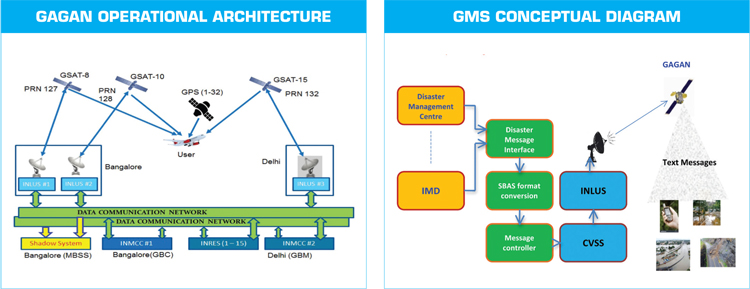
GMS CONCEPTUAL WORKING ARCHITECTURE
For the implementation of GMS, AAI has signed an MOU for the development of the Integrated Message Generation System (IMGS) with INCOIS. The alerts messages from the various agencies will be processed and converted into SBAS format along with priority as per the nature of the alert message. After processing the alert messages, IMGS will send the messages to the Correction & Verification Sub-system (CVSS) of GAGAN system. CVSS will make necessary correction & verification of the alert messages and after that, the alert messages will go to Indian Land Uplink Station (INLUS) of GAGAN system. INLUS will uplink the alert messages in accordance with assign priority to GAGAN geostationary satellites for the broadcast of the alert message.
The GAGAN enabled receiver which is configured to read the GAGAN message will receive the alert messages from GEO satellites, process it, extracts the ALERT/EARLY WARNING TEXT Messages and display the same. Also, the receiver gives the current location of the user from which he can identify whether he is currently in the affected area or not. Separate Apps can be developed to extract these Alert/Early warning messages from GAGAN signal through mobile phones. The application can support the display of broadcast messages in various Indian regional languages.
GAGAN GMS – A SOLUTION FOR BROADCASTING ADVANCE WARNING INFORMATION
The need for disbursal of timely information during natural distress is imperative. India is more susceptible to disasters caused by natural hazards and ranks second in the number of disasters and the number of people affected in the Asia-Pacific regions.
GAGAN satellites broadcast alert messages over Indian continent which could be utilized by any user having Smart-Phone, receiver or a device that can receive GAGAN satellite signal. As alert messages are available from satellite, it has a wider coverage area and easy to provide last-mile connectivity to the fishermen who travel very deep in the sea.
THE FACILITY OF TRANSMISSION OF SHORT MESSAGE THROUGH THE GAGAN SYSTEM IS PARTICULARLY USEFUL TO THE FISHING COMMUNITY THAT OPERATE FAR AWAY FROM THE INDIAN COASTAL REGIONS
GAGAN Message Service provides an opportunity to send alert messages and early warning messages over a wider area within a short time which will save lives and reduce the loss of property due to the occurrence of natural calamity.
Fishermen in deep-sea can receive information of Alert/warning messages of INCOIS where it is not possible to provide such information by conventional communications methods and in the areas of no mobile network coverage for the personnel living in mountain regions.
The potential stakeholders that can utilize the benefits of GMS for their services are the Indian Metrological Department (IMD), Snow & Avalanche Study Establishment (SASE), National Disaster Management Authority (NDMA), etc. The GAGAN Message service can also be used to broadcast information related to Potential Fishing Zone (PFZ) for fishermen.
GMS is a boon to overcome the problem of last-mile reach since the messages can be received directly from GAGAN GEO Satellites either on a hand-held GMS receiver for all users.
The thought was echoed by the Union Minister of Science & Technology and Earth Sciences, “I am happy that INCOIS joined hands with AAI and developed GAGAN Enabled Mariner’s Instrument for Navigation and Information (GEMINI) and worked out the technical procedures to uplink/downlink the information through GAGAN Systems”. He further added that “Potential fishing zones (PFZ) advisories have become part of the value chain of the fishing community and about 6.75 lakh active fishermen are regularly accessing advisories through information disseminated by INCOIS. Dissemination of alert/early warning messages and also PFZ Forecast Services will be very useful for fishermen community in the coastal areas of our country when their locations are based beyond the mobile coverage.”
SP's AirBuz - CURRENT ISSUE